|
|
Weather Alert |
| Portage County, OH | |||||||||
|
|
||||||||
|
Canceled 6/14/26 3:48 PM Tornado Warning issued June 14 at 3:30PM EDT until June 14 at 4:15PM EDT by NWS Cleveland OH TORCLE The National Weather Service in Cleveland has issued a * Tornado Warning for... Southwestern Portage County in northeastern Ohio... Northern Summit County in northeastern Ohio... * Until 415 PM EDT. * At 330 PM EDT, a severe thunderstorm capable of producing a tornado was located 7 miles northwest of Cuyahoga Falls, or 12 miles northwest of Akron, moving east at 40 mph. HAZARD...Tornado. SOURCE...Radar indicated rotation. IMPACT...Flying debris will be dangerous to those caught without shelter. Mobile homes will be damaged or destroyed. Damage to roofs, windows, and vehicles will occur. Tree damage is likely. * This dangerous storm will be near... Akron, Cuyahoga Falls, Hudson, and Streetsboro around 335 PM EDT. Kent and Tallmadge around 340 PM EDT. Ravenna around 350 PM EDT. Other locations impacted by this tornadic thunderstorm include Silver Lake, Brimfield, Brady Lake, Peninsula, Sugar Bush Knolls, Richfield, Boston Heights, Munroe Falls, Stow, and Brecksville. 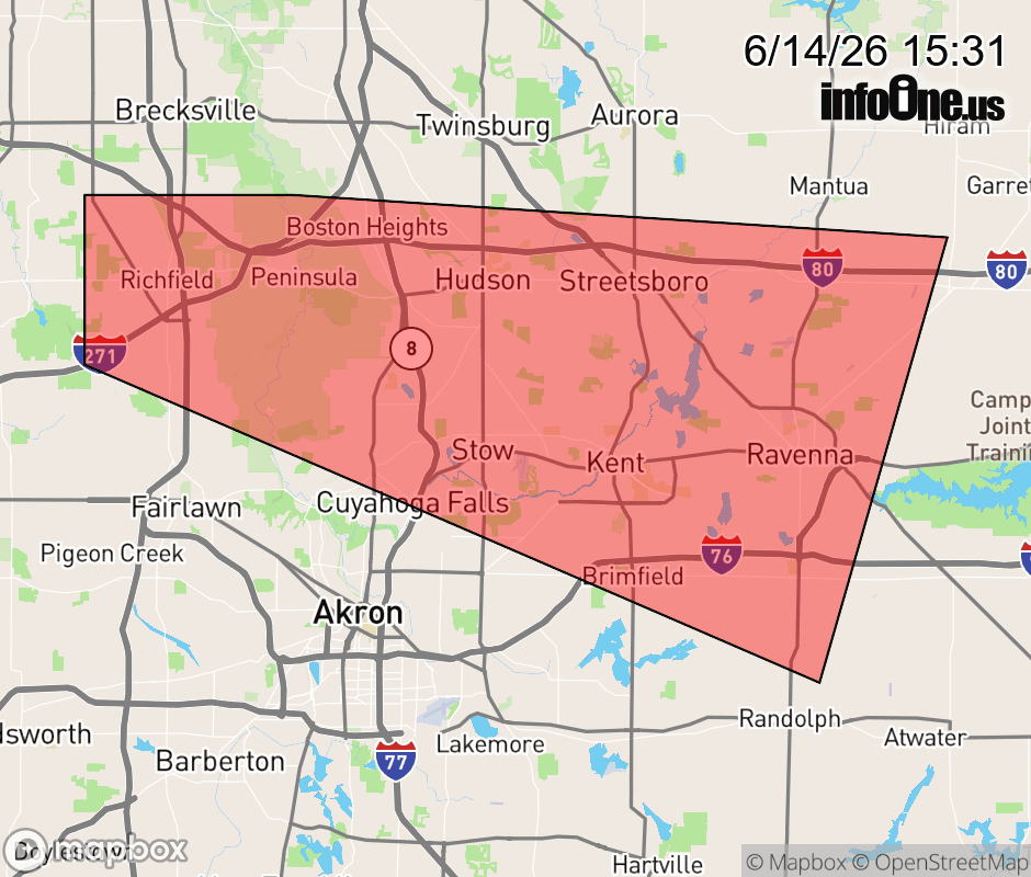 |
|||||||||
 Why aren't you using the InfoOne app? Why aren't you using the InfoOne app?
Stay abreast of information affecting your community! InfoOne tracks real-time information such as:
InfoOne currently supports over 100 communities in NC, VA and WV, and our coverage area is steadily growing. It's free! Install the InfoOne app today and see what you've been missing. |
|||||||||